COSEISMIQ in Brief
Over the last decade induced seismicity has become an important topic of discussion, especially owing to the concern that industrial activities could cause damaging earthquakes. Large magnitude induced seismic events are a risk for the population and structures, as well as an obstacle for the development of new techniques for the exploitation of underground georesources. The problem of induced seismicity is particularly important for the future development of geothermal energy in Europe. Induced seismicity is an unwanted product of such industrial operations but, at the same time, induced earthquakes are also a required mechanism to increase the permeability of rocks, enhancing reservoir performances. Analysis of induced microseismicity allows to obtain the spatial distribution of fractures within the reservoir, which can help, not only to identify active faults that may trigger large induced seismic events, but also to optimize hydraulic stimulation operations and to locate the regions with higher permeability, enhancing energy production.
The project COSEISMIQ integrates seismic monitoring and imaging techniques, geomechanical models and risk analysis methods with the ultimate goal of implementing innovative tools recently developed but yet untested. These adaptive, data driven approaches for reservoir optimization and for the control and management of induced seismicity represent a major contribution to safe and sustainable geothermal energy exploitation.
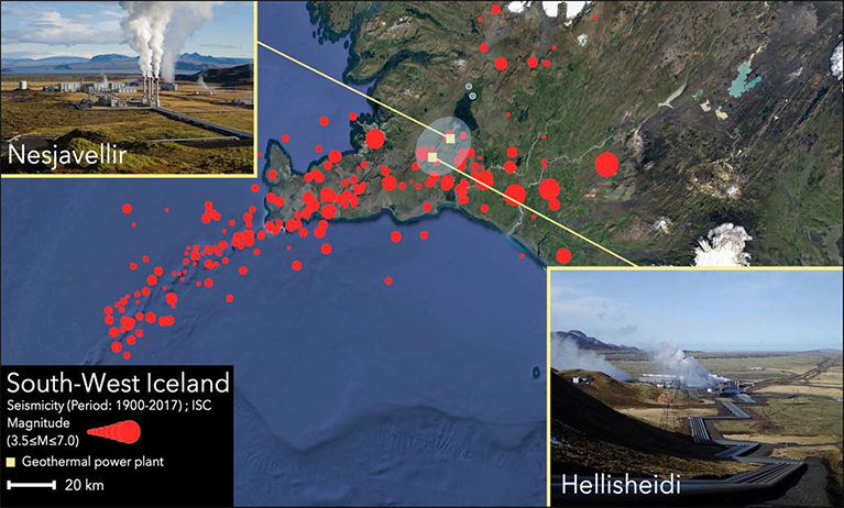
The selected demonstration site for this project is the Hengill region in Iceland, where the two largest geothermal power plants of the country are in operation, the Nesjavellir power stations and the Hellisheidi power station, the third largest geothermal power plant in the world. This demonstration site is ideal to test and validate COSEISMIQ technologies since there are many existing and commercially successful geothermal projects and induced seismicity is common, but it is much less of a risk governance challenge due to low population density and limited building fragility.
Map of South-West Iceland. Yellow squares indicate the two power plants, the demonstration sites of COSEISMIQ. Red dots represent seismicity from ISC catalogue (Magnitude >3.5; Time frame 01.0.1.1900 – 01.01.2017). The gray shaded area indicates the area where the seismic monitoring stations are installed.
